
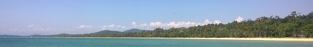
History of Mission Beach
Home of the traditional owners of the Djiru Aboriginal tribe
The district now known as Mission Beach is located on the coast north of Cardwell and was originally part of the Cardwell Division local government area constituted in 1884. This division included the area from the Hinchinbrook Channel in the south to Double Point near Mourilyan Harbour in the north. Later the boundaries were changed and the northern section of "Mission Beach" became part of the Johnstone Shire in February 1937.
However, although the beaches were included on maps, generally known as the "Clump Point" region, opening up for selection and actual settlement was slow in developing. The coastal floodplains of the Murray, Tully and Hull Rivers which discharge into Rockingham Bay are wetlands subject to extensive flooding in the wet season. Mangroves fringe the coast and movement in the area was very difficult for the first white settlers. It was not until the 1880's that the first settlers became established.
Aboriginal Heritage
The Dyiru-speaking Aboriginal people who inhabited this island coast were linguistically, culturally and socially related to the Dyirbal, Girramay and Gulngay groups of the Tully and Murray River districts. Hunters, fishers and gatherers of the rainforests and coast, they utilised the rich plant and animal resources to provide their needs. They excelled in making and using canoes and rafts and were expert fishermen of both fresh and marine waters.
Contact with early navigators and coastal surveyors as well as with beche-de-mer fishing boats was established long before the first white people settled the beach areas in 1882. Timber-getters also camped on the beaches during their cutting expeditions and occasionally utilised Aboriginal labour in return for tobacco or tools.
The Kennedy Expedition and Early Explorers
The ill-fated Edmund Kennedy Expedition of 1848 landed on the south side of Tam O'Shanter Point, which was named by Captain Stanley after the barque which brought the explorers from Sydney. A cairn was raised a century later to commemorate the landing. Kennedy had undertaken to travel north to Cape York and then down the western side of the peninsula, however, he was forced to turn south to find a way through the swamps and jungles of the coast. He crossed the Hull, Tully and Murray Rivers before being able to turn inland just north of what is now the present Cardwell
In 1873 Dalrymple undertook an expedition which explored the North East coast, and he reported favourably that the Rockingham Bay area was suitable for farming right back to the ranges. He praised the beauty and fertility of Dunk Island and was enthusiastic about the agricultural possibilities of the Clump Point region. Following his official report, this area was subsequently opened for selection as freehold land or leases.
Bingil Bay and 'Bicton'
The first permanent white settlers on the coast were the Cutten brothers who arrived at Bingil Bay on April 1 1882. At that time the Cardwell local government Division still took in the beaches but in 1885 most of Clump Point and north of that point were transferred to the Johnstone Division (North Mission Beach was transferred later).
Coastal shipping provided a lifeline from Bingil Bay to the settlement at Cardwell, which was visited by the coastal traffic passing between Townsville and Cairns. The Cuttens cleared the land and planted pineapples, bananas, coffee, tea, coconuts and other crops. The fruit and other produce were taken by sea to southern markets, picked up by the coastal steamers. A timber mill was also built here to take advantage of the silky oak and red cedar of the area.
The advancing years of the Cuttens, the withdrawal of coastal shipping during the First World War, and the destruction and losses to crops, boats and buildings during the 1918 cyclone led to the demise of the Bicton plantation.
Twenty years after the Cuttens took up their land, the Unsworths and the Porters arrived. Others to follow were the Garners, after whom Garners Beach is named, and later, at South Mission, the Reid cousins, who grew bananas, Morton, Beaman and Web.
The "Mission"
Chinese banana growers along the Tully River were numerous after 1900. They cleared garden plots and grew bananas that they sent to southern markets, loading them from their sampans onto the lighters which took the fruit out to the coastal steamer waiting at the river mouth. The Chinese employed Aboriginal labourers and opium addiction became a problem. Other problems arose from the inevitable conflict resulting from white settlers moving into the traditional hunting territories of the Aboriginal people. The Queensland Government proposed to establish the Hull River Aboriginal Settlement on high ground at the north end of what is now South Mission Beach to combat the opium and other problems. Superintendent John Martin Kenny arrived on 1 September 1914 and commenced organising the clearing and building of three large houses on the hillside overlooking the beach.
There was never an actual mission at the site and Aboriginal people from the local area and from elsewhere in Queensland were taken there in chains as if to a penal settlement. However, the local people always referred to the settlement as "the mission" and the beach became known as "Mission Beach".
The devastating cyclone of 1918 destroyed the establishment and no attempt was made at reconstruction. Instead, the Aboriginal people were removed to Palm Island, which was chosen as the preferred location for a new government settlement.
The 1918 Cyclone
On 10 March 1918 a furious cyclone and tidal wave swept across the area and wiped out the Aboriginal settlement at Hull River, the homes and the orchards of the scattered settlers on the coast. The afternoon the cyclone hit, a telephone link had been set up between Banyan (the forerunner of Tully township) and the "mission". It was not to be replaced for some time. During the cyclone the camping area at the beach was covered to a depth of ten feet by the tidal wave which swept away the bark and grass huts, and several people were also swept away and drowned. Superintendent Kenny and his daughter died, killed by flying debris, as did a number of Aboriginal people.
Roads to the Beaches
In the early days of the settlement of the beaches coastal communications were vital. Mail and supplies were brought in by sea and produce was sent to market by sea also. The North Coast Railway was not completed between Cairns and Townsville until 1924, passing inland of the beaches. While there were bridle tracks between the beaches for use when the tides prevented travel along the beaches themselves, and a track to Banyan, there were no made roads at all in the area prior to the 1920's
The construction of roads from the beaches to the new settlement beside the sugar mill at Tully and to the railhead at El Arish were vital to the expansion of the beach settlements. The first made road was completed by the P.E.I. (Public Estates Improvement) between El Arish and Bingil Bay in 1936, linked by a good gravel road to North Mission Beach.
A Township Surveyed
Although the Cardwell Shire Council and the Tully Chamber of Commerce had suggested in 1929 that a township at Mission Beach should be surveyed, this was not done due to lack of access roads to the beaches. After the PEI road from El Arish was opened in 1936, and the bridle track to Tully which had been improved by timbercutters, was also taken over by the PEI, access was considered adequate.
In 1939 a township was surveyed by D. Ryland; it was named Kenny, and the first lots went on sale at Tully Court House in December 1939. As none of the locals called it Kenny, it officially became what they did call it: South Mission Beach.
Canecutters who worked in the canefields of the Tully district often camped at Mission Beach during the slack season. By hunting and fishing they could supplement their diets and survive until the next canecutting season. The years of the depression were particularly difficult and many of the camps they set up became permanent.
Dunk Island
Dunk Island was named by Lt. James Cook after the Earl of Halifax, George Montague Dunk, when Cook sailed past the island on 9 June 1770. Edmund James Banfield, the famous Beachcomber who lived on Dunk from 1897 to his death in 1923, recorded that the Aboriginal name for the isle was Coonanglebah. Banfield was an ex-journalist from England who came to Townsville seeking respite from health and stress problems. He and his wife built a slab hut and then a bungalow on their 360 acres on the island and from here he made his observations and recorded his impressions of life on this piece of tropical paradise. In 1935 Hon. Hugo Brassey, an Englishman, bought 200 acres on the island and commenced the development of a resort and the building of an airstrip.
During WW2 Dunk Island was annexed by the RAAF and became home to secret radar equipment which was to play an instrumental role in the Battle of the Coral Sea. After the war the resort was again developed, particularly after it was purchased by Trans Australia Airlines in 1976. The majority of the island does still remain a National Park, allowing its natural beauty as well as its provisions for visitors to be fully appreciated.
Later Developments
Improved roads and communications ensured further developments at both North and South Mission Beach. The first regular store at North Mission was opened in 1947 by Mr. E. Boyett, who had moved to the beach from Innisfail. A Post Office was added two years later, and he also successfully agitated for an official telephone line, which came in from Tully in 1951.
Since the development of a decent road, South Mission has been a popular place among picnickers, weekenders and campers. Mission Beach Surf Life Savers' Club has been active for a number of years, with a clubhouse located at South Mission.
The first school house was mid-way between the two beach families who had children, the Webb and Dunlop families. They built the house on Dunlops' property at Wongaling Beach in about 1934. The four children studied by correspondence here under the guidance of a governess. The Mission Beach State School was established in 1953. In 1964 there were only 15 pupils on the roll who attended school in a small weatherboard building on Boyett Road. As attendance grew, a larger school was required. The new school premises were opened at Wongaling Beach in 1993.